
ALOMAR#
ALOMAR is located on the northwestern tip of Andøya (69.3°N, 16.0°E) on the summit of Mount Ramnan at an elevation of 378 m above sea level. Andøya lies approximately 50 km from mainland Norway and as such, lies at the crossroads of unobstructed air flowing into and out of the Arctic. This, in combination with its northern latitude above the Arctic Circle, makes it an excellent location to conduct cal/val activities. It is expected that EarthCARE will have one daytime overpass within 100 km per week.
The figure below shows the ALOMAR observatory, and we give a short overview over the instruments below. More detailed infos are available at the ALOMAR website.
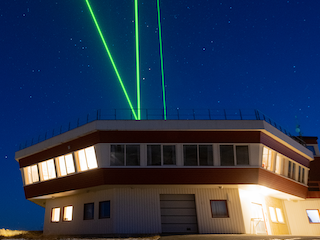
Fig. 9 Photo of the ALOMAR observatory with running lidars. Figure taken from the ALOMAR website.#
Instruments#
ALOMAR is the home to several remote sensing facilities including a tropospheric lidar (ATL) and a Cimel sun and moon photometer. The measurements from the ATL and Cimel are part of EARLINET and AERONET, respectively, and are associated with ACTRIS.
Tropospheric lidar (ATL)
The ATL operates with a pulsed Nd:YAG solid-state laser at 1064 nm and its second and third harmonic 532 and 355 nm, respectively. The detection channels include the three emitted wavelengths for elastic scattering and one for Raman scattering at 387 nm. Currently, the outgoing light at 532 nm is linearly polarized, and the receiver has been equipped with orthogonal and parallel polarization channels.
Cimel sun and moon photometer
The sun-sky-lunar Cimel CE318-T multiband photometer (Cimel Electronique) measures at 10 nominal wavelengths between 340 and 1020 nm. It has an approximate field of view of 1.29° and obtains aerosol and water vapor content through spectral direct-sun and direct-moon irradiance measurements. The Cimel is also able to infer aerosol properties from inversion during the daytime period using spectral sky radiances.